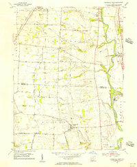
1955 Map of Commercial Point
USGS Topo · Published 1956About this map
The Scioto River valley south of Grove City defines this mid-century landscape, where the fertile plains are marked by a dense network of farm-to-market roads and long-established family landholdings. This 1955 survey documents the rural character of northern Pickaway County and southern Franklin County before modern suburban expansion. Small hubs like Commercial Point and Shadeville anchor the local economy, while the Baltimore and Ohio railroad cuts across the northwestern corner near Rensch Road.
Find a feature on this map
45 named features on this map. Tap any name to fly to it.
Don’t see what you’re looking for? This feature index may not catch every label — zoom into the map to look around manually.
Map Details
Editions of this 1955 Commercial Point Map
This is the sole edition of this map. No revisions or reprints were ever made.
Other maps of this area

1911 · Era
USGS Topo · 1:62,500

1913 · Era
USGS Topo · 1:62,500

1914 · Circleville
USGS Topo · 1:62,500

1923 · West Columbus
USGS Topo · 1:62,500

1925 · East Columbus
USGS Topo · 1:62,500

1925 · West Columbus
USGS Topo · 1:62,500

1943 · Era
USGS Topo · 1:62,500

1943 · Circleville
USGS Topo · 1:62,500

1943 · East Columbus
USGS Topo · 1:62,500

1947 · Columbus
USGS Topo · 1:250,000