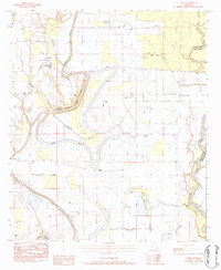
1983 Map of Como
USGS Topo · Published 1984About this map
Bayou Macon and its dramatic Bayou Macon Cutoff dominate this 1980s landscape at the boundary of Franklin Parish and Tensas Parish. The terrain is defined by a complex hydraulic network of oxbow lakes and backwaters, including Beeler Lake, Johnson Lake, and Wiley's Brake. The map illustrates the intensive water management of the era, featuring numerous levees and spoil banks that crisscross the wetlands.
Find a feature on this map
37 named features on this map. Tap any name to fly to it.
Don’t see what you’re looking for? This feature index may not catch every label — zoom into the map to look around manually.
Map Details
Editions of this 1983 Como Map
This is the sole edition of this map. No revisions or reprints were ever made.
Other maps of this area

1935 · Winnsboro
USGS Topo · 1:62,500

1935 · Shackleford Lake
USGS Topo · 1:62,500

1939 · Locust Ridge
USGS Topo · 1:62,500

1941 · Sicily Island
USGS Topo · 1:62,500

1953 · Natchez
USGS Topo · 1:250,000

1955 · Jackson
USGS Topo · 1:250,000

1956 · Natchez
USGS Topo · 1:250,000

1957 · Sicily Island
USGS Topo · 1:62,500

1958 · Shackleford Lake
USGS Topo · 1:62,500

1958 · Winnsboro
USGS Topo · 1:62,500