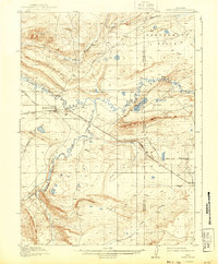
1918 Map of Como Ridge
USGS Topo · Published 1943About this map
Medicine Bow serves as the primary hub of this high-plains landscape, where the Union Pacific railroad tracks bisect the terrain. The settlement’s importance as a transportation center is underscored by the convergence of several primary regional routes, including the Hanna Road and Difficulty Road. Outside of town, the environment is defined by a series of prominent geological formations like Como Ridge and Saddleback Ridge, with the Medicine Bow River and Little Medicine Bow River carving courses through the basins. Evidence of early rural community life is found at the Ambler School and Kansas School, which served the scattered homesteads of the Greasewood Flats. Near Aurora Lake, the map labels Robbers Roost, a site whose name evokes the frontier history and folklore of Carbon and Albany counties during the early twentieth century.
Find a feature on this map
25 named features on this map. Tap any name to fly to it.
Don’t see what you’re looking for? This feature index may not catch every label — zoom into the map to look around manually.
Map Details
Editions of this 1918 Como Ridge Map
2 editions found
Other maps of this area

1914 · Saddleback Hills
USGS Topo · 1:62,500

1915 · Como Ridge
USGS Topo · 1:48,000

1918 · Como Ridge
USGS Topo · 1:62,500

1921 · Saddleback Hills
USGS Topo · 1:62,500

1954 · Torrington
USGS Topo · 1:250,000

1954 · Cheyenne
USGS Topo · 1:250,000

1954 · Rawlins
USGS Topo · 1:250,000

1955 · Pine Tree Ridge
USGS Topo · 1:24,000

1955 · Rock River
USGS Topo · 1:24,000

1955 · Wilcox
USGS Topo · 1:24,000