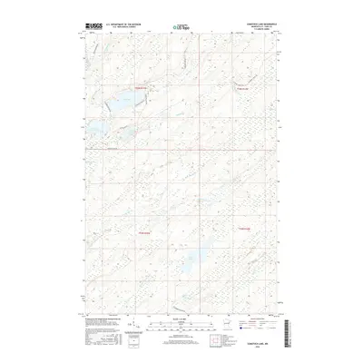
2016 Map of Comstock Lake
USGS Topo · Published 2016About this map
Comstock Lake and the winding course of the Whiteface River anchor this Saint Louis County landscape, a region defined by its dense network of glacial lakes and tributaries. The hydrography of the area is particularly complex, with Lower Comstock Lake, Hart Lake, and Hendrickson Lake forming a chain of water bodies connected by minor drainages like Gimlet Creek. Further south, the Big Kab-Wan-Ka River and Rush Lake dominate the terrain, reflecting the wetland-rich environment of northern Minnesota. Access to these remote waters is maintained through a modest network of local routes, including Comstock Lake Rd and Setterlund Dr, which serve the small lakeside clusters. This 2016 survey documents the enduring physical geography of the Iron Range backcountry, where the names of small creeks such as Coolidge Cr and Bug Creek reveal the local history of land use and navigation in the wilderness.
Find a feature on this map
26 named features on this map. Tap any name to fly to it.
Don’t see what you’re looking for? This feature index may not catch every label — zoom into the map to look around manually.
Map Details
Editions of this 2016 Comstock Lake Map
This is the sole edition of this map. No revisions or reprints were ever made.
Other maps of this area

1951 · Makinen
USGS Topo · 1:24,000

1953 · Shaw
USGS Topo · 1:24,000

1953 · Boulder Lake Reservoir
USGS Topo · 1:24,000

1954 · Thompson Lake
USGS Topo · 1:24,000

1954 · Hibbing
USGS Topo · 1:250,000

1956 · Whiteface
USGS Topo · 1:24,000

1957 · Hibbing
USGS Topo · 1:250,000

1957 · Markham
USGS Topo · 1:62,500

1957 · Comstock Lake
USGS Topo · 1:24,000
1957 · Boulder Lake Reservoir NE
USGS Topo · 1:24,000