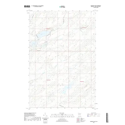
2019 Map of Comstock Lake
USGS Topo · Published 2019About this map
The Whiteface River meanders through the northwest corner of this St. Louis County landscape, which is defined by an extensive network of wetlands and interconnected water bodies. Significant features include Comstock Lake and its companion, Lower Comstock Lake, joined by a series of creeks such as Gimlet Creek. To the southeast, the terrain transitions toward Rush Lake and the winding Us-Kab-Wan-Ka River, reflecting a northern Minnesota environment where water dictates the movement of people and resources.
Find a feature on this map
25 named features on this map. Tap any name to fly to it.
Don’t see what you’re looking for? This feature index may not catch every label — zoom into the map to look around manually.
Map Details
Editions of this 2019 Comstock Lake Map
This is the sole edition of this map. No revisions or reprints were ever made.
Other maps of this area

1951 · Makinen
USGS Topo · 1:24,000

1953 · Shaw
USGS Topo · 1:24,000

1953 · Boulder Lake Reservoir
USGS Topo · 1:24,000

1954 · Thompson Lake
USGS Topo · 1:24,000

1954 · Hibbing
USGS Topo · 1:250,000

1956 · Whiteface
USGS Topo · 1:24,000

1957 · Hibbing
USGS Topo · 1:250,000

1957 · Markham
USGS Topo · 1:62,500

1957 · Comstock Lake
USGS Topo · 1:24,000
1957 · Boulder Lake Reservoir NE
USGS Topo · 1:24,000