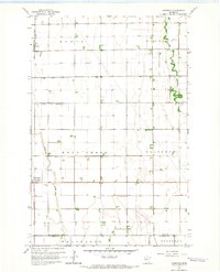
1964 Map of Comstock Lake
USGS Topo · Published 1966About this map
The agricultural landscape of the Red River Valley is defined by its extensive water management system, characterized here by a grid of engineered drainage features including County Ditch No 11, County Ditch No 36, and County Ditch No 50. These canals cross-cut the townships of Kurtz, Elm Wood, and Holy Cross, supporting the productive farmland that brackets the Great Northern railway. The village of Comstock serves as a local hub along the rail line, accompanied by the nearby Comstock Cem.
Find a feature on this map
17 named features on this map. Tap any name to fly to it.
Don’t see what you’re looking for? This feature index may not catch every label — zoom into the map to look around manually.
Map Details
Editions of this 1964 Comstock Lake Map
This is the sole edition of this map. No revisions or reprints were ever made.
Other maps of this area

1951 · Makinen
USGS Topo · 1:24,000

1953 · Shaw
USGS Topo · 1:24,000

1953 · Boulder Lake Reservoir
USGS Topo · 1:24,000

1954 · Thompson Lake
USGS Topo · 1:24,000

1954 · Hibbing
USGS Topo · 1:250,000

1956 · Whiteface
USGS Topo · 1:24,000

1957 · Hibbing
USGS Topo · 1:250,000

1957 · Markham
USGS Topo · 1:62,500

1957 · Comstock Lake
USGS Topo · 1:24,000
1957 · Boulder Lake Reservoir NE
USGS Topo · 1:24,000