
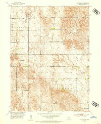
1952 Map of Comstock SE
USGS Topo · Published 1954About this map
Educational outposts anchor the rolling Nebraska hillsides in this survey of Valley County. The township boundaries of Michigan, Geranium, Liberty, and Vinton organize the landscape, where isolated schoolhouses serve as the primary landmarks for rural families. Small centers of learning like Highland Sch, New Yale Sch, and the evocatively named Hardscrabble Sch are distributed across the terrain, reflecting the density of small-plot agricultural life in the early 1950s. The topography is defined by the drainage systems of South Branch Turtle Creek, Dane Creek, and Hawthorne Creek, which carve through the high ground. This survey, conducted as part of the Department of the Interior program for the development of the Missouri River Basin, documents the precise location of section lines and early unimproved roads that connected these isolated prairie school districts before the consolidation of rural education.
Find a feature on this map
19 named features on this map. Tap any name to fly to it.
Don’t see what you’re looking for? This feature index may not catch every label — zoom into the map to look around manually.
Map Details
Editions of this 1952 Comstock SE Map
2 editions found
Other maps of this area

1899 · Loup
USGS Topo · 1:125,000

1951 · Arcadia West
USGS Topo · 1:24,000

1951 · Arcadia East
USGS Topo · 1:24,000

1952 · Elyria
USGS Topo · 1:24,000

1952 · Comstock
USGS Topo · 1:24,000

1952 · Comstock NW
USGS Topo · 1:24,000

1953 · Loup City NW
USGS Topo · 1:24,000

1954 · Ord
USGS Topo · 1:24,000

1954 · Ord NW
USGS Topo · 1:24,000

1955 · Broken Bow
USGS Topo · 1:250,000