
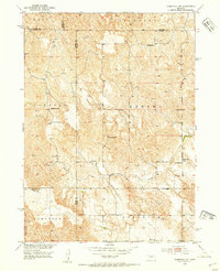
1952 Map of Comstock NW
USGS Topo · Published 1954About this map
The rolling tablelands at the intersection of Custer, Valley, Loup, and Garfield counties are meticulously documented in this mid-century survey. The landscape is defined by the headwaters of Turtle Creek and its North Branch, which carve through a rural grid shaped by early settlement patterns and immigrant heritage. One of the most significant cultural landmarks is the Bohemian Brotherhood Church and its adjacent Bohemian Brotherhood Cemetery, serving as a spiritual anchor for the Czech-American community near Jungmann Hall. The map reveals a dense network of country schoolhouses that once served this agricultural region, including Komensky School, Shady Hollow School, and Blue Grass School. To the south, Big Oak Canyon provides a sharp contrast to the more open reaches of the Comstock and Geranium districts, reflecting the diverse terrain found along the eastern edge of the Nebraska Sandhills.
Find a feature on this map
25 named features on this map. Tap any name to fly to it.
Don’t see what you’re looking for? This feature index may not catch every label — zoom into the map to look around manually.
Map Details
Editions of this 1952 Comstock NW Map
2 editions found
Other maps of this area

1952 · Burwell
USGS Topo · 1:24,000

1952 · Sargent East
USGS Topo · 1:24,000

1952 · Elyria
USGS Topo · 1:24,000

1952 · Sargent SE
USGS Topo · 1:24,000

1952 · Burwell SE
USGS Topo · 1:24,000

1952 · Comstock
USGS Topo · 1:24,000

1952 · Taylor SE
USGS Topo · 1:24,000

1952 · Comstock SE
USGS Topo · 1:24,000

1955 · Broken Bow
USGS Topo · 1:250,000

1956 · Broken Bow
USGS Topo · 1:250,000