
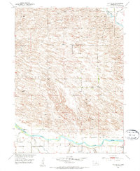
1952 Map of Taylor SE
USGS Topo · Published 1954About this map
Rural schoolhouses anchor the landscape of Loup County during the early 1950s, reflecting a dispersed ranching and farming community. Named landmarks like Lone Star Sch and Round Hill Sch dot the terrain, which is defined by the winding paths of the Calamus River to the north and the North Loup River to the south. The irrigation infrastructure of the Taylor-Ord Canal and various siphons and spill banks along the river bottom suggest the vital role of water management in this part of the Missouri River Basin development program.
Find a feature on this map
21 named features on this map. Tap any name to fly to it.
Don’t see what you’re looking for? This feature index may not catch every label — zoom into the map to look around manually.
Map Details
Editions of this 1952 Taylor SE Map
2 editions found
Other maps of this area

1952 · Burwell
USGS Topo · 1:24,000

1952 · Sargent East
USGS Topo · 1:24,000

1952 · Taylor NW
USGS Topo · 1:24,000

1952 · Sargent West
USGS Topo · 1:24,000

1952 · Comstock NW
USGS Topo · 1:24,000

1952 · Taylor
USGS Topo · 1:24,000

1952 · Burwell NW
USGS Topo · 1:24,000

1952 · Taylor NE
USGS Topo · 1:24,000

1955 · Broken Bow
USGS Topo · 1:250,000

1956 · Broken Bow
USGS Topo · 1:250,000