
1952 Map of Sargent West
USGS Topo · Published 1954About this map
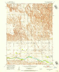
The Middle Loup River meanders across the southern portion of this landscape, protected by a prominent Levee near the settlement of Sargent. This 1952 field-checked survey reveals a rural landscape deeply organized around its early 20th-century social infrastructure, with numerous country schools including Blue Mound Sch, West Union Sch, and Tableland Sch distributed to serve the farming families of Madison Square and Lillian. The terrain is defined by dramatic erosional features like Crosley Canyon and Sand Canyon, which cut through the plateaus of West Union and Taylor. Local genealogy is well-preserved through the inclusion of several burial grounds, such as Mt Hope Cem, St Marys Cem, and West Union Cem, alongside the Zion Hill Sch, which served as a focal point for the community north of the river.
Find a feature on this map
23 named features on this map. Tap any name to fly to it.
Don’t see what you’re looking for? This feature index may not catch every label — zoom into the map to look around manually.
Map Details
Editions of this 1952 Sargent West Map
4 editions found
Other maps of this area

1951 · Walworth
USGS Topo · 1:24,000

1951 · Round Valley
USGS Topo · 1:24,000

1952 · Sargent East
USGS Topo · 1:24,000

1952 · Sargent SE
USGS Topo · 1:24,000

1952 · Taylor SE
USGS Topo · 1:24,000

1952 · Sargent SW
USGS Topo · 1:24,000

1952 · Almeria
USGS Topo · 1:24,000

1952 · Taylor
USGS Topo · 1:24,000

1955 · Broken Bow
USGS Topo · 1:250,000

1956 · Broken Bow
USGS Topo · 1:250,000