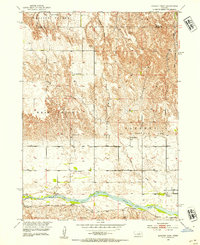
1952 Map of Sargent West
USGS Topo · Published 1954About this map
The Middle Loup River winds through the southern reaches of Custer County, shaping the local geography as it flows past the town of Sargent. This mid-century landscape reflects the organized agricultural divisions of the Nebraska Sandhills, partitioned into historic townships like Madison Square, West Union, and Lillian. The terrain is defined by deep erosion features such as Sand Canyon and Cheshire Canyon, with the prominent rise of Blue Mound serving as a distinct landmark in the central hills.
Find a feature on this map
19 named features on this map. Tap any name to fly to it.
Don’t see what you’re looking for? This feature index may not catch every label — zoom into the map to look around manually.
Map Details
Editions of this 1952 Sargent West Map
4 editions found
Other maps of this area

1951 · Walworth
USGS Topo · 1:24,000

1951 · Round Valley
USGS Topo · 1:24,000

1952 · Sargent East
USGS Topo · 1:24,000

1952 · Sargent SE
USGS Topo · 1:24,000

1952 · Sargent West
USGS Topo · 1:24,000

1952 · Taylor SE
USGS Topo · 1:24,000

1952 · Sargent SW
USGS Topo · 1:24,000

1952 · Almeria
USGS Topo · 1:24,000

1952 · Taylor
USGS Topo · 1:24,000

1955 · Broken Bow
USGS Topo · 1:250,000