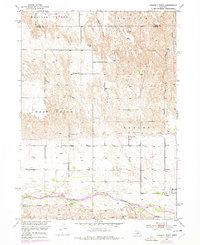
1952 Map of Sargent West
USGS Topo · Published 1978About this map
The Middle Loup River winds across the southern reaches of this Custer County landscape, defining the agricultural character of the region. This mid-century survey illustrates the vital role of irrigation and water management in the Nebraska sandhills, clearly marking the Sargent Canal and various ditches that divert water toward local farmsteads. The settlement pattern is anchored by the town of Sargent, which sits just north of the river and serves as the local hub for the surrounding townships of Sargent, West Union, and Lillian.
Find a feature on this map
24 named features on this map. Tap any name to fly to it.
Don’t see what you’re looking for? This feature index may not catch every label — zoom into the map to look around manually.
Map Details
Editions of this 1952 Sargent West Map
4 editions found
Other maps of this area

1951 · Walworth
USGS Topo · 1:24,000

1951 · Round Valley
USGS Topo · 1:24,000

1952 · Sargent East
USGS Topo · 1:24,000

1952 · Sargent SE
USGS Topo · 1:24,000

1952 · Sargent West
USGS Topo · 1:24,000

1952 · Taylor SE
USGS Topo · 1:24,000

1952 · Sargent SW
USGS Topo · 1:24,000

1952 · Almeria
USGS Topo · 1:24,000

1952 · Taylor
USGS Topo · 1:24,000

1955 · Broken Bow
USGS Topo · 1:250,000