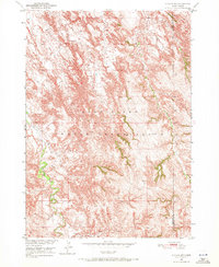
1950 Map of Conata SW
USGS Topo · Published 1972About this map
Pine Ridge Indian Reservation lands dominate this mid-century landscape, characterized by the intricate drainage systems of the Missouri River Basin. The topography reveals the complex erosional patterns of the South Dakota Badlands, where seasonal watercourses like Redwater Creek and Mud Creek carve deep through the terrain. A historical boundary between Shannon Co and Washabaugh Co is clearly delineated in the eastern portion of the sheet, reflecting administrative divisions of the era. The land is largely defined by these natural contours and the path of Potato Creek, showing a region largely undeveloped and preserved in its natural state during the 1950 field check.
Find a feature on this map
5 named features on this map. Tap any name to fly to it.
Don’t see what you’re looking for? This feature index may not catch every label — zoom into the map to look around manually.
Map Details
Editions of this 1950 Conata SW Map
2 editions found
Other maps of this area

1950 · Conata
USGS Topo · 1:24,000

1950 · Conata SW
USGS Topo · 1:24,000

1950 · Imlay SE
USGS Topo · 1:24,000

1950 · Bouquet Table
USGS Topo · 1:24,000

1952 · Conata NE
USGS Topo · 1:24,000

1952 · Bouquet Table
USGS Topo · 1:24,000

1952 · Conata SE
USGS Topo · 1:24,000

1952 · Conata
USGS Topo · 1:24,000

1955 · Hot Springs
USGS Topo · 1:250,000

1981 · Wall
USGS Topo · 1:100,000