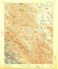
1915 Map of Concord
USGS Topo · Published 1923About this map
Southern Pacific rail lines and early California ranchos define the landscape in this early twentieth-century survey of the East Bay. The map illustrates the transition from the large Mexican land grants, such as the Laguna De Los Palos Colorados Tract No. 2, to the growing towns of Concord, Walnut Creek, and Lafayette. The intricate topography of the San Leandro Hills and As Trampas Ridge is rendered in sharp detail, showing the deep canyons and peaks like Grizzly Peak and Bald Peak that overlook the burgeoning city of Oakland. Local historians will note the numerous small stops and settlements like Hookston, Saranap, and Meinert, many of which were tied to the rail corridor. The presence of rural landmarks such as the Redwood Inn and the Country Club reflects the early suburban and recreational development spreading into the valleys of San Ramon Creek and Arroyo del Hambre.
Find a feature on this map
111 named features on this map. Tap any name to fly to it.
Don’t see what you’re looking for? This feature index may not catch every label — zoom into the map to look around manually.
Map Details
Editions of this 1915 Concord Map
5 editions found

Other maps of this area

1892 · San Mateo
USGS Topo · 1:62,500

1895 · San Francisco
USGS Topo · 1:62,500

1896 · San Mateo
USGS Topo · 1:62,500

1896 · Carquinez Strait
USGS Topo · 1:62,500

1896 · Mt. Diablo
USGS Topo · 1:62,500

1897 · Concord
USGS Topo · 1:62,500

1898 · Karquines
USGS Topo · 1:62,500

1898 · Mt. Diablo
USGS Topo · 1:62,500

1899 · San Francisco
USGS Topo · 1:62,500

1899 · Haywards
USGS Topo · 1:62,500