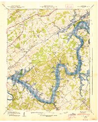
1940 Map of Concord
USGS Topo · Published 1947About this map
The Tennessee River flows through this 1940 survey of the borderlands between Knox, Loudon, and Blount counties, revealing a river system in transition as the Fort Loudoun Reservoir and Watts Bar Res are delineated. Historically significant river crossings are documented, including the Leeper Ferry, which is noted as abandoned by the time of the field examination. The river is dotted with numerous islands and shoals, such as Cane Island and Bussell Shoals, which define the complex waterway before it reaches Bussell Island at the junction with the Little Tennessee River.
Find a feature on this map
69 named features on this map. Tap any name to fly to it.
Don’t see what you’re looking for? This feature index may not catch every label — zoom into the map to look around manually.
Map Details
Editions of this 1940 Concord Map
4 editions found
Other maps of this area

1895 · Loudon
USGS Topo · 1:125,000

1935 · Binfield
USGS Topo · 1:24,000

1935 · Meadow
USGS Topo · 1:24,000

1935 · Lenoir City
USGS Topo · 1:24,000

1935 · Bethel Valley
USGS Topo · 1:24,000

1935 · Bearden
USGS Topo · 1:24,000

1935 · Lovell
USGS Topo · 1:24,000

1936 · Louisville
USGS Topo · 1:24,000

1936 · Friendship
USGS Topo · 1:48,000

1936 · Loudon
USGS Topo · 1:24,000