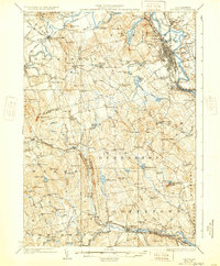
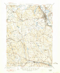
1927 Map of Concord
USGS Topo · Published 1932About this map
The Merrimack River corridor and the capital city of Concord dominate this 1920s landscape, serving as a hub for the Boston and Maine RR and the Electric Road. The city is densely gridded, featuring the State Prison, the Hospital, and the sprawling grounds of St Pauls School. Beyond the urban center, the terrain is defined by a series of prominent hills like Rum Hill and Pine Hill, while the Piscataquog River and Contoocook River systems support a network of small mill towns and agricultural settlements.
Find a feature on this map
104 named features on this map. Tap any name to fly to it.
Don’t see what you’re looking for? This feature index may not catch every label — zoom into the map to look around manually.
Map Details
Editions of this 1927 Concord Map
6 editions found
Other maps of this area

1900 · Peterboro
USGS Topo · 1:62,500

1905 · Manchester
USGS Topo · 1:62,500

1906 · Milford
USGS Topo · 1:62,500

1919 · Gilmanton
USGS Topo · 1:62,500

1921 · Suncook
USGS Topo · 1:62,500

1926 · Hillsboro
USGS Topo · 1:62,500

1927 · Concord
USGS Topo · 1:62,500

1927 · Penacook
USGS Topo · 1:62,500

1927 · Gilmanton
USGS Topo · 1:62,500

1928 · Mount Kearsarge
USGS Topo · 1:62,500