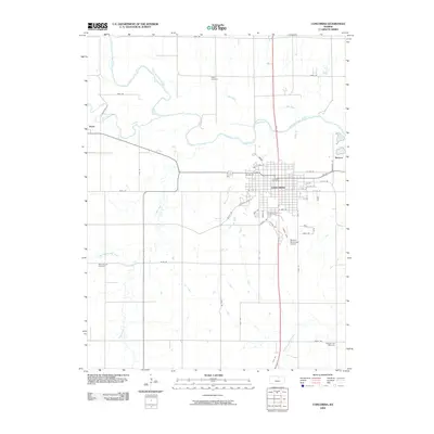
2009 Map of Concordia
USGS Topo · Published 2009About this map
Concordia serves as the central hub of this Kansas landscape, situated south of a prominent bend in the Republican River. The town's grid is well-established, anchored by the Concordia Post Office and extending south toward the Blosser Municipal Airport. Surrounding the city, the rural character of Cloud County is defined by a network of drainage systems including Buffalo Creek, Hay Creek, and Cool Creek, which feed into the primary river valley. For genealogists and local historians, several burial grounds are preserved across the quadrangle, including the centrally located Pleasant Hill Cemetery, the northern Sibley Cemetery, and the West Branch Cemetery to the southwest. Smaller rural points like Yuma and Rosaco mark the transitions between the concentrated urban center and the expansive agricultural sections defined by roads like Vale Rd and Noble Rd.
Find a feature on this map
55 named features on this map. Tap any name to fly to it.
Don’t see what you’re looking for? This feature index may not catch every label — zoom into the map to look around manually.
Map Details
Editions of this 2009 Concordia Map
This is the sole edition of this map. No revisions or reprints were ever made.
Other maps of this area

1892 · Concordia
USGS Topo · 1:125,000

1892 · Minneapolis
USGS Topo · 1:125,000

1953 · Glasco NE
USGS Topo · 1:24,000

1955 · Manhattan
USGS Topo · 1:250,000

1956 · Manhattan
USGS Topo · 1:250,000

1957 · Manhattan
USGS Topo · 1:250,000

1965 · Aurora
USGS Topo · 1:24,000
1965 · Aurora NW
USGS Topo · 1:24,000

1965 · Wayne
USGS Topo · 1:24,000

1965 · Concordia NW
USGS Topo · 1:24,000