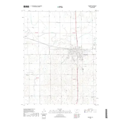
2018 Map of Concordia
USGS Topo · Published 2018About this map
The Republican River winds prominently through this Cloud County landscape, shaping the development of Concordia and its surrounding agricultural reaches. The street grid of the county seat is clearly delineated, stretching from W 1st St south toward the local aviation hub at Blosser Municipal Airport. This 2018 survey provides an essential look at the region's burial grounds and small settlements, including Sibley Cem to the north and Saint Concordia Cem within the town limits. Outlying areas like Yuma and Rosaco are documented alongside a complex drainage network featuring Buffalo Creek, Wolf Cr, and Cool Cr. For the genealogist or local researcher, the map preserves the exact locations of family landmarks such as Pleasant Hill Cem and West Branch Cem, situated among the section lines and county roads like Noble Rd and Quail Rd that define the Kansas prairie.
Find a feature on this map
99 named features on this map. Tap any name to fly to it.
Don’t see what you’re looking for? This feature index may not catch every label — zoom into the map to look around manually.
Map Details
Editions of this 2018 Concordia Map
This is the sole edition of this map. No revisions or reprints were ever made.
Other maps of this area

1892 · Concordia
USGS Topo · 1:125,000

1892 · Minneapolis
USGS Topo · 1:125,000

1953 · Glasco NE
USGS Topo · 1:24,000

1955 · Manhattan
USGS Topo · 1:250,000

1956 · Manhattan
USGS Topo · 1:250,000

1957 · Manhattan
USGS Topo · 1:250,000

1965 · Aurora
USGS Topo · 1:24,000
1965 · Aurora NW
USGS Topo · 1:24,000

1965 · Wayne
USGS Topo · 1:24,000

1965 · Concordia NW
USGS Topo · 1:24,000