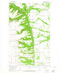
1964 Map of Concrete
USGS Topo · Published 1965About this map
Concrete lies in the north-central portion of this mid-1960s landscape, where the deeply incised valleys of the Tongue River and its tributaries break the North Dakota plains. The map illustrates a distinctive pattern of land use, with dense township and range section lines crossing the upland plateaus of Beaulieu, South Olga, and East Alma, while the rugged coulees remain largely wooded and undeveloped. This survey, completed as part of the Department of the Interior program for the development of the Missouri River Basin, shows the region's agricultural and rural foundation. Genealogists and local historians can find important community landmarks including St Ellens Cem and West Mountain Cem, along with the Olson Dam and various Gravel Pits that supported local infrastructure. The boundary between Cavalier Co and Pembina Co runs through the lower third of the sheet, dividing the townships of Thingvalla, Montrose, and Gardar.
Find a feature on this map
19 named features on this map. Tap any name to fly to it.
Don’t see what you’re looking for? This feature index may not catch every label — zoom into the map to look around manually.
Map Details
Editions of this 1964 Concrete Map
This is the sole edition of this map. No revisions or reprints were ever made.
Other maps of this area

1918 · Walhalla
USGS Topo · 1:62,500

1943 · Walhalla
USGS Topo · 1:62,500

1952 · Thief River Falls
USGS Topo · 1:250,000

1953 · Devils Lake
USGS Topo · 1:250,000

1956 · Thief River Falls
USGS Topo · 1:250,000

1956 · Devils Lake
USGS Topo · 1:250,000

1957 · Thief River Falls
USGS Topo · 1:250,000

1963 · Gardar
USGS Topo · 1:24,000

1964 · Mountain
USGS Topo · 1:24,000

1964 · Hallson
USGS Topo · 1:24,000