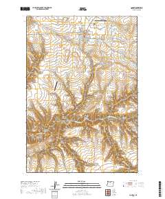
2020 Map of Condon
USGS Topo · Published 2020About this map
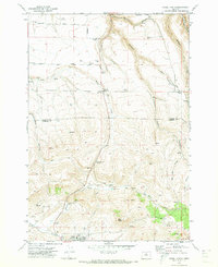
Condon serves as the focal point of this Gilliam County landscape, characterized by a series of deep drainage systems that feed into Thirtymile Cr. The town's civic core is anchored by the Gilliam County Courthouse, while the northern edge is marked by a concentration of fraternal and religious burial grounds, including the Masonic Cem, King of Peace Cem, and the Independent Order of Odd Fellows Cem. The surrounding plateau is dissected by numerous named canyons such as Sniption Canyon, Condon Canyon, and Greiner Canyon. These landforms, along with high-elevation features like Beecher Flat and the prominent ridge of Devils Backbone, illustrate the complex erosion patterns typical of this portion of the Oregon high desert. Transportation and infrastructure are represented by Condon State Pauling Field and the Condon Reservoir, which provide essential services to this agricultural region.
Find a feature on this map
54 named features on this map. Tap any name to fly to it.
Don’t see what you’re looking for? This feature index may not catch every label — zoom into the map to look around manually.
Map Details
Editions of this 2020 Condon Map
This is the sole edition of this map. No revisions or reprints were ever made.
Other maps of this area

1916 · Condon
USGS Topo · 1:125,000

1953 · The Dalles
USGS Topo · 1:250,000

1956 · The Dalles
USGS Topo · 1:250,000

1957 · The Dalles
USGS Topo · 1:250,000

1970 · Igo Butte
USGS Topo · 1:24,000
1970 · Schott Canyon
USGS Topo · 1:24,000

1970 · Condon
USGS Topo · 1:24,000
1970 · Salmon Fork
USGS Topo · 1:24,000
1970 · Buckhorn Canyon
USGS Topo · 1:24,000
1970 · Fossil North
USGS Topo · 1:24,000