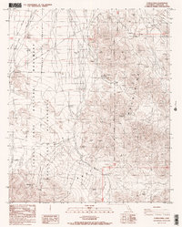
1986 Map of Conejo Well
USGS Topo · Published 1987About this map
Joshua Tree National Monument and the surrounding desert landscape are captured here during a mid-1980s field check. The terrain is defined by the sharp rise of the Eagle Mountains and the broad expanse of the Pinto Basin, where seasonal drainage is marked by features like Smoke Tree Wash. Resource extraction and desert travel are evident through the Storm Jade Mine and the winding Black Eagle Mine Road, which cuts through the arid environment. A notable point of human activity in this parched region is Conejo Well (Dry), an essential waypoint for earlier travelers that is shown here as a dry feature. The map clearly delineates the Joshua Tree National Wilderness and its boundaries, providing a detailed record of land management and primitive 4WD Road access before the area's further transition into modern park status.
Find a feature on this map
12 named features on this map. Tap any name to fly to it.
Don’t see what you’re looking for? This feature index may not catch every label — zoom into the map to look around manually.
Map Details
Editions of this 1986 Conejo Well Map
2 editions found
Other maps of this area

1940 · Cottonwood Spring
USGS Topo · 1:62,500

1940 · Canyon Spring
USGS Topo · 1:62,500

1943 · Canyon Spring
USGS Topo · 1:62,500

1943 · Pinkham Well
USGS Topo · 1:62,500

1944 · Cottonwood Spring
USGS Topo · 1:62,500

1944 · Pinkham Well
USGS Topo · 1:62,500

1944 · Eagle Tank
USGS Topo · 1:62,500

1954 · Salton Sea
USGS Topo · 1:250,000

1955 · Salton Sea
USGS Topo · 1:250,000
1958 · Cottonwood Spring
USGS Topo · 1:62,500