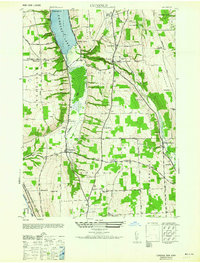
1964 Map of Conesus
USGS Topo · Published 1964About this map
Conesus Lake anchors this mid-century view of Livingston County, where the shoreline transition from the recreation-focused Cottonwood Pt and Maple Beach to the sprawling Inlet marshland defines the local geography. The landscape is a network of small agricultural settlements and crossroads, including Scottsburg and Websters Crossing, linked by a series of town-line roads and the paths of the Erie Railroad and Delaware Lackawanna and Western.
Find a feature on this map
41 named features on this map. Tap any name to fly to it.
Don’t see what you’re looking for? This feature index may not catch every label — zoom into the map to look around manually.
Map Details
Editions of this 1964 Conesus Map
This is the sole edition of this map. No revisions or reprints were ever made.
Other maps of this area

1901 · Honeoye
USGS Topo · 1:62,500

1902 · Wayland
USGS Topo · 1:62,500

1904 · Wayland
USGS Topo · 1:62,500

1904 · Caledonia
USGS Topo · 1:62,500

1904 · Honeoye
USGS Topo · 1:62,500

1905 · Nunda
USGS Topo · 1:62,500

1942 · Springwater
USGS Topo · 1:31,680

1942 · Wayland
USGS Topo · 1:31,680
1942 · Honeoye
USGS Topo · 1:31,680

1942 · Dansville
USGS Topo · 1:31,680