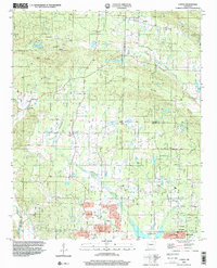
1994 Map of Congo
USGS Topo · Published 2000About this map
Hurricane Creek and its many tributaries, including Little Hurricane Creek and Coney Creek, define the drainage patterns of this central Arkansas landscape. The area is marked by a network of rural communities and crossroads, from the more established Bryant in the southeast to the smaller settlements of Avilla, Congo, and Salem. Local history is preserved in numerous community centers, such as Congo Ch, Lawson Ch, and Holly Springs Ch, alongside several family and community burial grounds like Pipkin Cem and Rose Garden Cem.
Find a feature on this map
32 named features on this map. Tap any name to fly to it.
Don’t see what you’re looking for? This feature index may not catch every label — zoom into the map to look around manually.
Map Details
Editions of this 1994 Congo Map
This is the sole edition of this map. No revisions or reprints were ever made.
Other maps of this area

1890 · Benton
USGS Topo · 1:125,000

1891 · Little Rock
USGS Topo · 1:125,000

1893 · Little Rock
USGS Topo · 1:125,000

1894 · Benton
USGS Topo · 1:125,000

1935 · Alexander
USGS Topo · 1:48,000

1938 · Benton
USGS Topo · 1:48,000

1941 · Alexander
USGS Topo · 1:62,500

1943 · Pinnacle Mtn
USGS Topo · 1:31,680

1944 · Benton
USGS Topo · 1:62,500

1944 · Alexander
USGS Topo · 1:31,680