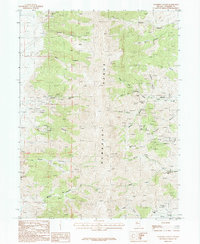
1987 Map of Congress Canyon
USGS Topo · Published 1988About this map
The Humboldt Range dominates this late-twentieth-century landscape, revealing a high-desert terrain deeply scarred by mining history. In the eastern foothills, the settlements of Unionville and Buena Vista sit near the mouth of Buena Vista Creek, serving as focal points for the extensive mineral exploration documented across the slopes. The map is a meticulous record of extractive industry, noting dozens of specific sites including the Standard Mine, Inskip Mine, and Arizona Mine, alongside specialized infrastructure like the Straight Tunnel and Boston Tunnel. Drainage patterns are sharply defined through Congress Canyon and Monitor Canyon, while the western side of the range features the Rye Patch Mine and the Little Tungsten Mine nestled in the drainages of Rye Patch Canyon. This survey captures the region just as modern mapping techniques were being finalized, preserving the locations of numerous unnamed prospects and adits that point to a long legacy of prospecting.
Find a feature on this map
42 named features on this map. Tap any name to fly to it.
Don’t see what you’re looking for? This feature index may not catch every label — zoom into the map to look around manually.
Map Details
Editions of this 1987 Congress Canyon Map
This is the sole edition of this map. No revisions or reprints were ever made.
Other maps of this area

1931 · Lovelock
USGS Topo · 1:250,000

1935 · Lovelock
USGS Topo · 1:250,000

1954 · Unionville
USGS Topo · 1:62,500

1955 · Lovelock
USGS Topo · 1:250,000

1956 · Oreana
USGS Topo · 1:62,500

1956 · Imlay
USGS Topo · 1:62,500

1959 · Lovelock
USGS Topo · 1:250,000

1971 · Rye Patch Reservoir South
USGS Topo · 1:24,000

1984 · Lovelock
USGS Topo · 1:100,000
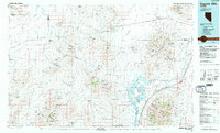
1985 · Eugene Mts
USGS Topo · 1:100,000