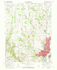
1972 Map of Connersville
USGS Topo · Published 1973About this map
Connersville serves as the industrial and civic anchor of this East Central Indiana landscape, situated along the Whitewater River. The city is defined by its extensive rail infrastructure, where the Penn Central, Norfolk and Western, and Baltimore and Ohio railroads converge. This transit network supported a dense residential and municipal core, featuring landmarks like the Courthouse, City Hall, and several neighborhood schools including Maplewood Sch and Grandview Sch. To the north and west, the terrain transitions into a grid of rural roads and farmsteads, punctuated by small community centers like Bentonville and Harrisburg. Waterways such as Williams Creek and Lick Creek cut through the countryside, while the presence of the Canal near Beesons reflects the area's earlier 19th-century transport legacy. Numerous family and community burial grounds, such as Little Creek Cem and Martin Cem, provide significant touchpoints for local genealogical research.
Find a feature on this map
71 named features on this map. Tap any name to fly to it.
Don’t see what you’re looking for? This feature index may not catch every label — zoom into the map to look around manually.
Map Details
Editions of this 1972 Connersville Map
2 editions found
Other maps of this area

1948 · Lewisville
USGS Topo · 1:24,000

1950 · Lewisville
USGS Topo · 1:24,000

1953 · Cincinnati
USGS Topo · 1:250,000

1956 · Everton
USGS Topo · 1:24,000

1956 · Alpine
USGS Topo · 1:24,000

1956 · Brownsville
USGS Topo · 1:24,000

1956 · Connersville
USGS Topo · 1:24,000

1957 · Cincinnati
USGS Topo · 1:250,000

1959 · New Salem
USGS Topo · 1:24,000

1959 · Falmouth
USGS Topo · 1:24,000