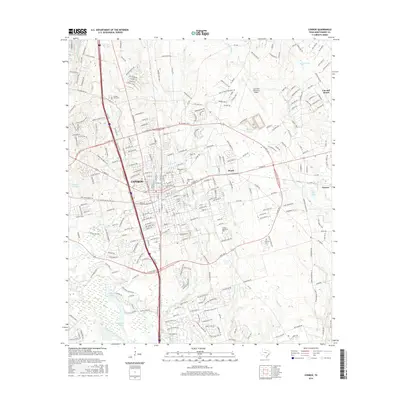
2016 Map of Conroe
USGS Topo · Published 2016About this map
The city of Conroe serves as the focal point of this Montgomery County landscape, where the dense residential street grids meet a network of surrounding drainage systems and smaller settlements. Several historic burial grounds are preserved within the urban fabric, including Oakwood Cem and Rosewood Cem, providing critical landmarks for genealogists tracing family ties in the region. To the east, the landscape transitions toward the aptly named community of Cut and Shoot and the settlement of Beach, while the Lone Star Executive Airport occupies a significant tract north of the town center.
Find a feature on this map
281 named features on this map. Tap any name to fly to it.
Don’t see what you’re looking for? This feature index may not catch every label — zoom into the map to look around manually.
Map Details
Editions of this 2016 Conroe Map
This is the sole edition of this map. No revisions or reprints were ever made.
Other maps of this area

1954 · Beaumont
USGS Topo · 1:250,000

1957 · Beaumont
USGS Topo · 1:250,000

1958 · Conroe
USGS Topo · 1:24,000

1958 · Cowl Spur
USGS Topo · 1:24,000

1958 · Lake Paula
USGS Topo · 1:24,000

1959 · Outlaw Pond
USGS Topo · 1:24,000

1959 · Cut and Shoot
USGS Topo · 1:24,000

1959 · Conroe NE
USGS Topo · 1:24,000

1960 · Willis
USGS Topo · 1:24,000
1961 · Tamina
USGS Topo · 1:24,000