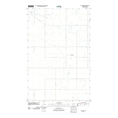
2011 Map of Considine
USGS Topo · Published 2011About this map
The small settlement of Considine stands as a central landmark in this portion of Towner County, North Dakota. Situated in a landscape defined by glacial potholes and prairie wetlands, the area is organized by an extensive grid of section roads including 63rd Ave NE and 80th St NE. The diagonal path of Bisbee Rd cuts through the otherwise rigid township-and-range lines in the northwest, suggesting a transportation corridor that predates or bypasses the standard grid. This map documents a sparsely populated agricultural region where the natural topography of scattered water bodies continues to influence the placement of rural infrastructure and homesteads.
Find a feature on this map
16 named features on this map. Tap any name to fly to it.
Don’t see what you’re looking for? This feature index may not catch every label — zoom into the map to look around manually.
Map Details
Editions of this 2011 Considine Map
This is the sole edition of this map. No revisions or reprints were ever made.
Other maps of this area

1953 · Devils Lake
USGS Topo · 1:250,000

1956 · Devils Lake
USGS Topo · 1:250,000

1957 · Cando
USGS Topo · 1:24,000

1962 · Egeland SW
USGS Topo · 1:24,000

1962 · Snyder Lake
USGS Topo · 1:24,000

1971 · Bisbee South
USGS Topo · 1:24,000

1971 · Considine
USGS Topo · 1:24,000

1971 · Leeds NE
USGS Topo · 1:24,000

1971 · Bisbee North
USGS Topo · 1:24,000
1971 · Big Coulee Dam
USGS Topo · 1:24,000