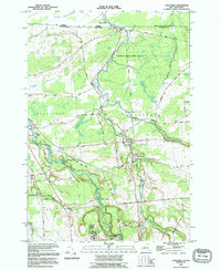
1993 Map of Constable
USGS Topo · Published 1995About this map
The international border between Canada and the United States defines the northern edge of this North Country landscape, where the Port of Entry US Customs station sits at the hamlet of Trout River. Moving south from the Quebec and New York boundary, the terrain is shaped by the meandering courses of the Trout River and the Salmon River, which flow through a mix of woodland and agricultural clearings. The village of Constable serves as a central hub, surrounded by a network of family-named roads like O Connell Road and Mc Graw Road. Local genealogy is well-preserved through several burial grounds, including the St Francis Of Assisi Cem and Methodist Cem, while the eastern portion of the map is dominated by the dense canopy of Franklin State Forest No 6.
Find a feature on this map
51 named features on this map. Tap any name to fly to it.
Don’t see what you’re looking for? This feature index may not catch every label — zoom into the map to look around manually.
Map Details
Editions of this 1993 Constable Map
This is the sole edition of this map. No revisions or reprints were ever made.
Other maps of this area

1915 · Chateaugay
USGS Topo · 1:62,500

1915 · Malone
USGS Topo · 1:62,500

1917 · Malone
USGS Topo · 1:62,500

1943 · Chateaugay
USGS Topo · 1:62,500

1948 · Ogdensburg
USGS Topo · 1:250,000

1951 · Ogdensburg
USGS Topo · 1:250,000

1953 · Ogdensburg
USGS Topo · 1:250,000

1961 · Ogdensburg
USGS Topo · 1:250,000
1964 · Ft. Covington
USGS Topo · 1:24,000
1964 · Burke
USGS Topo · 1:24,000