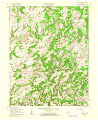
1960 Map of Constantine
USGS Topo · Published 1962About this map
The Rough River winds through the heart of this landscape, its path carving deep valleys through the Kentucky countryside at the start of the 1960s. This survey, updated from earlier photography, shows the winding course of the Rough River Reservoir as it begins to take shape in the southern half of the quadrangle. The terrain is defined by prominent elevations like Laurel Ridge and the Arch, while the boundary between Breckinridge and Hardin counties cuts through the western hills near the settlement of Dyer.
Find a feature on this map
30 named features on this map. Tap any name to fly to it.
Don’t see what you’re looking for? This feature index may not catch every label — zoom into the map to look around manually.
Map Details
Editions of this 1960 Constantine Map
2 editions found
Other maps of this area

1928 · Hardinsburg
USGS Topo · 1:48,000

1931 · Hardinsburg
USGS Topo · 1:62,500

1932 · Big Clifty
USGS Topo · 1:62,500

1941 · Ekron
USGS Topo · 1:62,500

1947 · Garfield
USGS Topo · 1:24,000

1947 · Hardinsburg
USGS Topo · 1:62,500

1947 · Ekron
USGS Topo · 1:62,500
1948 · Flaherty
USGS Topo · 1:24,000
1948 · Big Spring
USGS Topo · 1:24,000

1949 · Constantine
USGS Topo · 1:24,000