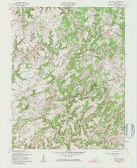
1960 Map of Constantine
USGS Topo · Published 1983About this map
The Rough River snakes through the borderlands of Hardin and Breckinridge Counties, carved into a landscape of deep hollows and prominent rises like Laurel Ridge. This 1960 revision reflects a rural Kentucky environment where small, crossroads communities like Constantine and Vertrees serve as anchors for the surrounding farmsteads. The importance of local congregation and memory is evident in the numerous small landmarks scattered throughout the hills, including Pole Bridge Ch, Smith Chapel, and the Godwin Cem.
Find a feature on this map
27 named features on this map. Tap any name to fly to it.
Don’t see what you’re looking for? This feature index may not catch every label — zoom into the map to look around manually.
Map Details
Editions of this 1960 Constantine Map
2 editions found
Other maps of this area

1928 · Hardinsburg
USGS Topo · 1:48,000

1931 · Hardinsburg
USGS Topo · 1:62,500

1932 · Big Clifty
USGS Topo · 1:62,500

1941 · Ekron
USGS Topo · 1:62,500

1947 · Garfield
USGS Topo · 1:24,000

1947 · Hardinsburg
USGS Topo · 1:62,500

1947 · Ekron
USGS Topo · 1:62,500
1948 · Flaherty
USGS Topo · 1:24,000
1948 · Big Spring
USGS Topo · 1:24,000

1949 · Constantine
USGS Topo · 1:24,000