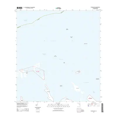
2015 Map of Content Keys
USGS Topo · Published 2015About this map
The Atlantic Ocean surrounds the low-lying mangrove islands and submerged flats of Monroe County in this 2015 survey. The map details the intricate marine geography of the Florida Keys, where natural passages like Content Passage and Big Spanish Channel provide navigation through the shallow banks. This region is defined by a scattered archipelago including the Content Keys, Cutoe Key, and Howe Key, many of which are protected by extensive mangrove fringes such as the Little Spanish Key Mangrove.
Find a feature on this map
25 named features on this map. Tap any name to fly to it.
Don’t see what you’re looking for? This feature index may not catch every label — zoom into the map to look around manually.
Map Details
Editions of this 2015 Content Keys Map
This is the sole edition of this map. No revisions or reprints were ever made.
Other maps of this area

1921 · Sugar Loaf Key
USGS Topo · 1:62,500

1943 · Sugarloaf Key
USGS Topo · 1:24,000

1972 · Big Pine Key
USGS Topo · 1:24,000
1972 · Sawyer Key
USGS Topo · 1:24,000

1972 · Horseshoe Keys
USGS Topo · 1:24,000

1972 · Content Keys
USGS Topo · 1:24,000

1972 · Summerland Key
USGS Topo · 1:24,000
1972 · Sugarloaf Key
USGS Topo · 1:24,000

1983 · Key West
USGS Topo · 1:100,000

1989 · Key West
USGS Topo · 1:250,000