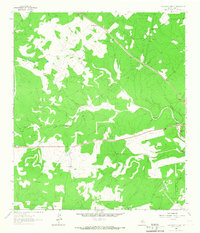
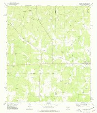
1964 Map of Contrary Creek
USGS Topo · Published 1967About this map
Midway Station and Mountain Home serve as the primary hubs in this corner of the Hill Country, where the landscape is defined by the winding paths of Johnson Creek and Contrary Creek. The topography is marked by a network of drainage systems, including the aptly named Rough Hollow, which feed into the larger creek basins. This 1964 field-checked survey reveals a rural economy dependent on scattered resources, evidenced by multiple Gravel Pit sites and the East Windmill. Transportation in this era is characterized by local routes and a specialized Landing Strip, suggesting a reliance on light aircraft for connectivity in the more isolated stretches of the county. The proximity of Contrary Spring to the creek that shares its name illustrates the vital role of natural water sources for the small settlements and ranching operations established here in the mid-1960s.
Find a feature on this map
11 named features on this map. Tap any name to fly to it.
Don’t see what you’re looking for? This feature index may not catch every label — zoom into the map to look around manually.
Map Details
Editions of this 1964 Contrary Creek Map
This is the sole edition of this map. No revisions or reprints were ever made.
Other maps of this area

1894 · Kerrville
USGS Topo · 1:125,000

1954 · Llano
USGS Topo · 1:250,000

1955 · Llano
USGS Topo · 1:250,000

1956 · Llano
USGS Topo · 1:250,000

1964 · Boneyard Draw
USGS Topo · 1:24,000
1964 · Bee Caves Creek
USGS Topo · 1:24,000

1964 · Live Oak Ranch
USGS Topo · 1:24,000
1964 · Mountain Home
USGS Topo · 1:24,000
1964 · Hunt
USGS Topo · 1:24,000
1974 · Harper West
USGS Topo · 1:24,000