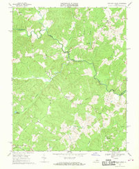
1968 Map of Contrary Creek
USGS Topo · Published 1970About this map
North Anna River flows through the center of this rural landscape at the border of Louisa and Spotsylvania Counties. The 1968 field survey reveals a terrain defined by water power and community centers, including Whitlock Millpond and Lacy Millpond, which reflect the area's agricultural and milling roots. Small rural settlements like Glenora and Holladay are scattered along winding country roads, often centered around local houses of worship such as Bethel Ch and Good Hope Ch. In the southern reaches of the quadrangle, the Chesapeake and Ohio railroad cuts across the land near Plum Tree, providing a vital transit link for the regional economy. The numerous unnamed cemeteries (Cem) marked near Edgewood Ch and Laurel Hill Ch offer significant points of interest for genealogists tracing family histories in this part of Virginia.
Find a feature on this map
23 named features on this map. Tap any name to fly to it.
Don’t see what you’re looking for? This feature index may not catch every label — zoom into the map to look around manually.
Map Details
Editions of this 1968 Contrary Creek Map
This is the sole edition of this map. No revisions or reprints were ever made.
Other maps of this area

1887 · Spottsylvania
USGS Topo · 1:125,000

1890 · Goochland
USGS Topo · 1:125,000

1892 · Spottsylvania
USGS Topo · 1:125,000

1892 · Goochland
USGS Topo · 1:125,000

1942 · Mineral
USGS Topo · 1:31,680

1942 · Lahore
USGS Topo · 1:31,680

1942 · Partlow
USGS Topo · 1:31,680

1942 · Belmont
USGS Topo · 1:31,680

1942 · Contrary Creek
USGS Topo · 1:31,680

1942 · Brokenburg
USGS Topo · 1:31,680