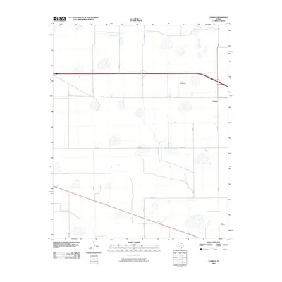
2010 Map of Conway
USGS Topo · Published 2010About this map
Conway serves as the focal point of this Panhandle landscape, situated at a major crossroads in Carson County. The surrounding terrain is defined by a grid of rural routes such as Alpha Rd and Charlie Rd, reflecting the organized agricultural layout of the Texas plains. A notable pocket of activity exists near Eagles Aerodrome, while the northern reaches of the quadrangle are carved by the intermittent path of McClellan Creek. This 2010 survey highlights the intersection of modern transportation and established community landmarks, including the Claude Cemetery in the southeastern corner. The map captures the balance between the vast open ranch lands and the essential infrastructure that connects this part of the Llano Estacado to the broader region via routes like Fm 2161 and Fm 3330.
Find a feature on this map
21 named features on this map. Tap any name to fly to it.
Don’t see what you’re looking for? This feature index may not catch every label — zoom into the map to look around manually.
Map Details
Editions of this 2010 Conway Map
This is the sole edition of this map. No revisions or reprints were ever made.
Other maps of this area

1953 · Sevenmile Basin
USGS Topo · 1:24,000

1954 · Amarillo
USGS Topo · 1:250,000

1956 · Washburn
USGS Topo · 1:24,000

1958 · Amarillo
USGS Topo · 1:250,000

1960 · Fairview
USGS Topo · 1:24,000

1960 · Claude
USGS Topo · 1:62,500

1966 · Panhandle West
USGS Topo · 1:24,000

1966 · Panhandle East
USGS Topo · 1:24,000
1983 · Claude
USGS Topo · 1:24,000
1983 · Claude SW
USGS Topo · 1:24,000