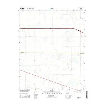
2016 Map of Conway
USGS Topo · Published 2016About this map
The High Plains of the Texas Panhandle are defined here by a stark, systematic grid of section roads and the prominent junction at Conway. This 2016 survey highlights the intersection of modern transit and historical land divisions, where state routes and county roads like FM 2161 and Co RD K carve the landscape into precise agricultural blocks. The terrain is marked by numerous small depressions and playas, with the ephemeral headwaters of McClellan Cr appearing in the north. At the southern edge of the quadrangle, the Claude Cem provides a specific point of interest for genealogists, while the presence of Eagles Aerodrome near the interstate corridor illustrates the region's continued reliance on expansive transportation networks. The division between Carson Co and Armstrong Co cuts straight through this landscape, influencing the placement of secondary routes like Alpha Rd and Bravo Rd.
Find a feature on this map
27 named features on this map. Tap any name to fly to it.
Don’t see what you’re looking for? This feature index may not catch every label — zoom into the map to look around manually.
Map Details
Editions of this 2016 Conway Map
This is the sole edition of this map. No revisions or reprints were ever made.
Other maps of this area

1953 · Sevenmile Basin
USGS Topo · 1:24,000

1954 · Amarillo
USGS Topo · 1:250,000

1956 · Washburn
USGS Topo · 1:24,000

1958 · Amarillo
USGS Topo · 1:250,000

1960 · Fairview
USGS Topo · 1:24,000

1960 · Claude
USGS Topo · 1:62,500

1966 · Panhandle West
USGS Topo · 1:24,000

1966 · Panhandle East
USGS Topo · 1:24,000
1983 · Claude
USGS Topo · 1:24,000
1983 · Claude SW
USGS Topo · 1:24,000