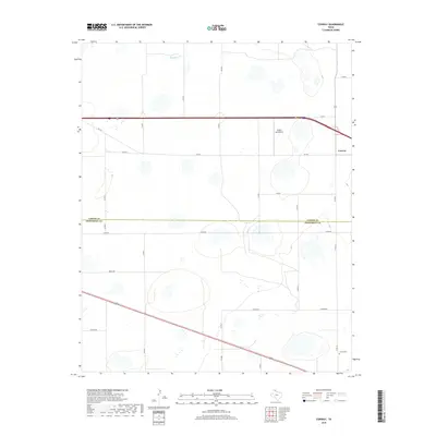
2019 Map of Conway
USGS Topo · Published 2019About this map
The community of Conway occupies the high plains at the intersection of major regional thoroughfares, serving as a focal point for this section of the Texas Panhandle. This landscape is defined by its rectilinear grid of rural roads and the dramatic boundary between Carson Co and Armstrong Co that bisects the quadrangle. Significant landmarks include the Eagles Aerodrome and the Claude Cem located in the southeastern corner, reflecting the area's ongoing settlement and utility. Beyond the highway corridors like FM 2161 and FM 3330, the terrain is punctuated by intermittent water features including McClellan Cr, which meanders through the northern section. The naming conventions for local routes such as Alpha Rd, Bravo Rd, and Charlie Rd suggest a modern, systematic approach to organizing this agricultural and ranching expanse.
Find a feature on this map
27 named features on this map. Tap any name to fly to it.
Don’t see what you’re looking for? This feature index may not catch every label — zoom into the map to look around manually.
Map Details
Editions of this 2019 Conway Map
This is the sole edition of this map. No revisions or reprints were ever made.
Other maps of this area

1953 · Sevenmile Basin
USGS Topo · 1:24,000

1954 · Amarillo
USGS Topo · 1:250,000

1956 · Washburn
USGS Topo · 1:24,000

1958 · Amarillo
USGS Topo · 1:250,000

1960 · Fairview
USGS Topo · 1:24,000

1960 · Claude
USGS Topo · 1:62,500

1966 · Panhandle West
USGS Topo · 1:24,000

1966 · Panhandle East
USGS Topo · 1:24,000
1983 · Claude
USGS Topo · 1:24,000
1983 · Claude SW
USGS Topo · 1:24,000