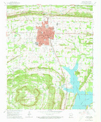
1961 Map of Conway
USGS Topo · Published 1973About this map
Hendrix College and State Teachers College anchor the academic core of Conway as it appeared in the early 1960s, a period when the city served as a primary education and rail hub. The Missouri Pacific railroad cuts through the center of town, passing the local Courthouse and Post Office before heading south toward the smaller settlements of Brumley and Preston. To the south, the recently completed Lake Conway defines the lowland geography, bordered by the rising elevations of Pine Mountain and Round Mountain. This landscape transition is punctuated by numerous rural landmarks, from the Mt Gale Ch near the Fish Hatchery to the Quarry and Shale Pits that suggest local extractive industries. The presence of specialized facilities like the Arkansas Childrens Home and the Conway Municipal Airport reflects a growing mid-century municipality expanding into the surrounding timber and farmland.
Find a feature on this map
63 named features on this map. Tap any name to fly to it.
Don’t see what you’re looking for? This feature index may not catch every label — zoom into the map to look around manually.
Map Details
Editions of this 1961 Conway Map
4 editions found

Other maps of this area

1890 · Benton
USGS Topo · 1:125,000

1891 · Little Rock
USGS Topo · 1:125,000

1892 · Morrillton
USGS Topo · 1:125,000

1893 · Little Rock
USGS Topo · 1:125,000

1894 · Morrillton
USGS Topo · 1:125,000

1894 · Benton
USGS Topo · 1:125,000

1953 · Cato
USGS Topo · 1:24,000

1953 · Mayflower
USGS Topo · 1:24,000

1955 · Little Rock
USGS Topo · 1:250,000

1956 · Little Rock
USGS Topo · 1:250,000