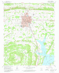
1961 Map of Conway
USGS Topo · Published 1980About this map
Conway serves as a bustling hub of education and transport in the early 1960s, defined by its numerous academic institutions like State Teachers College, Central College, and several specialized secondary schools. The city's structure is deeply influenced by the Missouri Pacific railroad, which cuts through the urban center near the Courthouse. To the south, the landscape shifts dramatically where the waters of Lake Conway dominate the terrain, managed by a spillway near the small settlement of Preston. The map reveals a transition from the dense street grids of the county seat to the rural ridges of Cadron Ridge and Pine Mountain. Significant community landmarks, such as the Arkansas Childrens Home and the Fairground, illustrate the civic life of the era, while outlying cemeteries like Macedonia Cem and Oak Grove Cemetery provide valuable data for local genealogists tracing family footprints across Faulkner County.
Find a feature on this map
61 named features on this map. Tap any name to fly to it.
Don’t see what you’re looking for? This feature index may not catch every label — zoom into the map to look around manually.
Map Details
Editions of this 1961 Conway Map
4 editions found

Other maps of this area

1890 · Benton
USGS Topo · 1:125,000

1891 · Little Rock
USGS Topo · 1:125,000

1892 · Morrillton
USGS Topo · 1:125,000

1893 · Little Rock
USGS Topo · 1:125,000

1894 · Morrillton
USGS Topo · 1:125,000

1894 · Benton
USGS Topo · 1:125,000

1953 · Cato
USGS Topo · 1:24,000

1953 · Mayflower
USGS Topo · 1:24,000

1955 · Little Rock
USGS Topo · 1:250,000

1956 · Little Rock
USGS Topo · 1:250,000