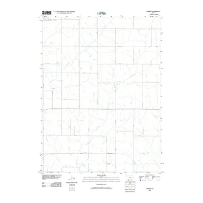
2010 Map of Conway
USGS Topo · Published 2010About this map
Conway anchors the northern edge of this Taylor County landscape, reflecting a rural Iowa community structured by a rigorous grid of section-line roads. The terrain is defined by the drainage systems of Honey Creek in the northwest and Platte Branch winding through the southeast. These waterways influence the placement of early cultural markers, including Bower Cemetery near the western boundary and the Platteville Cemetery further south. The small settlement of Platteville sits near the crossing of 280th St and Tennessee Ave, illustrating the historical importance of these rural crossroads. Researchers can trace the layout of numerous county roads, from Rockwood Ave to Winchester Ave, which provide access to the agricultural parcels that have long sustained this region.
Find a feature on this map
27 named features on this map. Tap any name to fly to it.
Don’t see what you’re looking for? This feature index may not catch every label — zoom into the map to look around manually.
Map Details
Editions of this 2010 Conway Map
This is the sole edition of this map. No revisions or reprints were ever made.
Other maps of this area

1940 · Blockton
USGS Topo · 1:62,500

1940 · Bedford
USGS Topo · 1:62,500

1943 · Bedford
USGS Topo · 1:62,500

1943 · Blockton
USGS Topo · 1:62,500

1955 · Nebraska City
USGS Topo · 1:250,000

1957 · Nebraska City
USGS Topo · 1:250,000

1958 · Nebraska City
USGS Topo · 1:250,000

1980 · Gravity
USGS Topo · 1:24,000

1980 · Merle Junction
USGS Topo · 1:24,000
1980 · Bedford
USGS Topo · 1:24,000