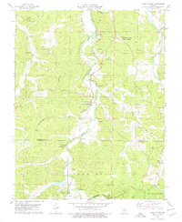
1978 Map of Cook Station
USGS Topo · Published 1979About this map
The Meramec River winds through the heart of the Ozark foothills, framing a landscape shaped by both the railroad and the region's mineral wealth. Along the corridor of the St Louis-San Francisco line, the small communities of Cook Station and Wesco serve as focal points for the surrounding rural townships of Union and Short Bend. The era's industrial heritage is clearly marked by several extraction sites, including a Coal Pit, Claypit, and Iron Pit, while historical Charcoal Ovens near Benton Creek point to earlier smelting practices.
Find a feature on this map
40 named features on this map. Tap any name to fly to it.
Don’t see what you’re looking for? This feature index may not catch every label — zoom into the map to look around manually.
Map Details
Editions of this 1978 Cook Station Map
This is the sole edition of this map. No revisions or reprints were ever made.
Other maps of this area

1928 · Meramec Spring
USGS Topo · 1:62,500

1932 · Steelville
USGS Topo · 1:48,000

1933 · Steelville
USGS Topo · 1:62,500

1937 · Steelville
USGS Topo · 1:62,500

1941 · Salem
USGS Topo · 1:62,500

1941 · Stone Hill
USGS Topo · 1:62,500

1945 · Salem
USGS Topo · 1:62,500

1945 · Stone Hill
USGS Topo · 1:62,500

1949 · Rolla
USGS Topo · 1:250,000

1949 · Meramec Spring
USGS Topo · 1:62,500