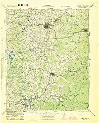
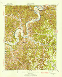
1944 Map of Cookeville
USGS Topo · Published 1944About this map
The Cumberland Plateau dominates the eastern landscape of this mid-1940s survey, rising sharply above the winding Caney Fork River and Calfkiller River systems. This map records the industrial and hydroelectric development of the region, featuring both the Burgess Falls Dam and Great Falls Dam. At the junction of regional transport, Cookeville and Monterey anchor the plateau's edge, while smaller mountain settlements like Bon Air and Ravenscroft reflect the historical mining and timber presence in the highlands. The geography revealed here shows a complex network of river crossings and ridges, including Hodge Ferry and the rugged topography of Dughill. Land use varies from the dense Bledsoe State Forest to the clustered communities along the Central Tennessee corridor, providing a detailed look at the rural infrastructure of the Highland Rim before post-war modernization.
Find a feature on this map
99 named features on this map. Tap any name to fly to it.
Don’t see what you’re looking for? This feature index may not catch every label — zoom into the map to look around manually.
Map Details
Editions of this 1944 Cookeville Map
This is the sole edition of this map. No revisions or reprints were ever made.
Other maps of this area

1892 · Pikeville
USGS Topo · 1:125,000

1893 · Mc Minnville
USGS Topo · 1:125,000

1895 · Mc Minnville
USGS Topo · 1:125,000

1895 · Pikeville
USGS Topo · 1:125,000

1897 · Standingstone
USGS Topo · 1:125,000

1898 · Standingstone
USGS Topo · 1:125,000
1909 · Sequatchie Valley
USGS Topo · 1:62,500
1910 · Pikeville
USGS Topo · 1:62,500
1912 · Crossville
USGS Topo · 1:62,500
1925 · Gainesboro
USGS Topo · 1:62,500