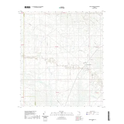
2021 Map of Cooks Hammock
USGS Topo · Published 2021About this map
Cooks Hammock serves as a primary settlement point in this Lafayette County landscape, where the flatwoods are defined by an intricate network of wetlands and seasonal drainages. The Steinhatchee River cuts through the southeastern corner, fed by local tributaries like Patterson Branch and Alligator Br. Local history is anchored at the Cooks Hammock Cem, located near the intersection of several forest roads including Chicken Penn Rd and S Mayo Dr. The terrain is characterized by numerous depressions and isolated water bodies such as Wolf Pond, Dowdy Pond, and the Willow Slough. Navigation through the dense Oaky Heads and timberlands relies on a grid of rural routes and specialized landmarks like the R O Ranch Airport, reflecting the region's contemporary mix of traditional land use and private aviation.
Find a feature on this map
45 named features on this map. Tap any name to fly to it.
Don’t see what you’re looking for? This feature index may not catch every label — zoom into the map to look around manually.
Map Details
Editions of this 2021 Cooks Hammock Map
This is the sole edition of this map. No revisions or reprints were ever made.
Other maps of this area

1954 · Mallory Swamp NW
USGS Topo · 1:24,000

1954 · Fenholloway
USGS Topo · 1:24,000

1954 · Day SE
USGS Topo · 1:24,000

1954 · Clara
USGS Topo · 1:24,000

1954 · Salem SW
USGS Topo · 1:24,000

1954 · Mallory Swamp SW
USGS Topo · 1:24,000

1954 · Cooks Hammock
USGS Topo · 1:24,000

1954 · Salem
USGS Topo · 1:24,000

1954 · Gainesville
USGS Topo · 1:250,000

1954 · Valdosta
USGS Topo · 1:250,000