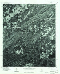
1975 Map of Cooks Springs
USGS Topo · Published 1977About this map
Cooks Springs and the surrounding ridgelines of St. Clair County are captured in this mid-1970s orthophotoquad, which uses rectified aerial imagery to document the landscape. The geography is defined by a series of parallel northeast-trending ridges, with development concentrated primarily along the lower-lying valley floors. The major transport corridor bisecting the quadrangle provides a stark contrast to the heavily wooded slopes and agricultural clearings found near Moody. In the southern reaches, smaller settlements like Prescott and Lawley mark the transition into more densely forested terrain. Produced in cooperation with the Soil Conservation Service, this imagery-based study reveals the exact patterns of timber harvesting, land clearing, and residential growth as they existed in the years following the expansion of the regional highway system.
Find a feature on this map
4 named features on this map. Tap any name to fly to it.
Don’t see what you’re looking for? This feature index may not catch every label — zoom into the map to look around manually.
Map Details
Editions of this 1975 Cooks Springs Map
This is the sole edition of this map. No revisions or reprints were ever made.
Other maps of this area

1889 · Springville
USGS Topo · 1:125,000

1889 · Birmingham
USGS Topo · 1:125,000

1890 · Bessemer
USGS Topo · 1:125,000

1890 · Talladega
USGS Topo · 1:125,000

1892 · Birmingham
USGS Topo · 1:125,000

1892 · Springville
USGS Topo · 1:125,000

1892 · Talladega
USGS Topo · 1:125,000

1892 · Bessemer
USGS Topo · 1:125,000

1895 · Birmingham
USGS Topo · 1:125,000

1905 · Leeds
USGS Topo · 1:62,500