
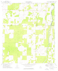
1974 Map of Cooktown
USGS Topo · Published 1976About this map
Cooktown serves as the focal point of this rural Southwest Georgia landscape during the mid-1970s, situated along the county line between Miller and Baker counties. The area is defined by a dense network of country churches, suggesting a deeply rooted community life across the agricultural plains. Notable houses of worship include Little Zion Ch, St Pauls Ch, and Cooks Union Ch, which sit alongside the waters of Cook Pond and Davis Pond. To the east, the terrain transitions toward the Flint River, where the Baker and Mitchell County line is established. This survey captures a moment when local aviation and industry left subtle marks on the land, evidenced by a Landing Strip and a Sandpit near Notchaway Ch. Small family and community landmarks like Kelly Cem and Bellview provide essential reference points for genealogists researching this corner of the state.
Find a feature on this map
22 named features on this map. Tap any name to fly to it.
Don’t see what you’re looking for? This feature index may not catch every label — zoom into the map to look around manually.
Map Details
Editions of this 1974 Cooktown Map
This is the sole edition of this map. No revisions or reprints were ever made.
Other maps of this area

1953 · Dothan
USGS Topo · 1:250,000

1954 · Dothan
USGS Topo · 1:250,000

1955 · Dothan
USGS Topo · 1:250,000

1956 · Newton
USGS Topo · 1:62,500

1971 · Vada
USGS Topo · 1:24,000

1971 · Hopeful
USGS Topo · 1:24,000

1974 · Boykin
USGS Topo · 1:24,000

1974 · Damascus
USGS Topo · 1:24,000

1974 · Elmodel
USGS Topo · 1:24,000
1974 · Steinham Store
USGS Topo · 1:24,000