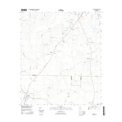
2014 Map of Coolidge
USGS Topo · Published 2014About this map
The boundary between Colquitt Co and Thomas Co divides this South Georgia landscape, where agricultural fields are punctuated by small rural settlements and meandering waterways. The Ochlockonee River winds through the northwestern corner, joined by tributaries such as Big Cr and Little Cr. Transportation in the region is anchored by the Moultrie Municipal Airport and a network of named country roads that connect local hamlets. Small communities like Murphy, Sunset, and Autreyville are scattered across the terrain, while the larger town of Coolidge sits at a crossroads in the southwest. Several family and community burial grounds, including Murphy Cem and County Line Cem, provide important landmarks for genealogical research. The layout of the roads and the placement of these cemeteries reflect a long-standing pattern of rural settlement and local industry in the area surrounding the county line.
Find a feature on this map
91 named features on this map. Tap any name to fly to it.
Don’t see what you’re looking for? This feature index may not catch every label — zoom into the map to look around manually.
Map Details
Editions of this 2014 Coolidge Map
This is the sole edition of this map. No revisions or reprints were ever made.
Other maps of this area

1953 · Waycross
USGS Topo · 1:250,000

1954 · Valdosta
USGS Topo · 1:250,000

1957 · Thomasville
USGS Topo · 1:62,500

1958 · Valdosta
USGS Topo · 1:250,000

1958 · Waycross
USGS Topo · 1:250,000

1959 · Valdosta
USGS Topo · 1:250,000

1961 · Quitman
USGS Topo · 1:62,500

1974 · Pineboro
USGS Topo · 1:24,000
1974 · Hartsfield
USGS Topo · 1:24,000
1975 · Merrillville
USGS Topo · 1:24,000