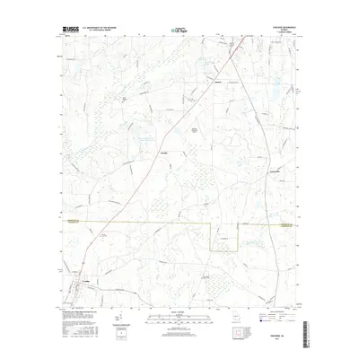
2017 Map of Coolidge
USGS Topo · Published 2017About this map
The Ochlockonee River flows through the northwest corner of this South Georgia landscape, where the agricultural flats of Thomas County and Colquitt County meet. The settlement of Coolidge anchors the southwest, while smaller communities like Murphy and Sunset sit along the central transit corridor. The geography is defined by a network of drainage creeks including Big Creek and Hog Creek, feeding into larger water bodies such as Bridge Creek Structure Number Eight Lake.
Find a feature on this map
85 named features on this map. Tap any name to fly to it.
Don’t see what you’re looking for? This feature index may not catch every label — zoom into the map to look around manually.
Map Details
Editions of this 2017 Coolidge Map
This is the sole edition of this map. No revisions or reprints were ever made.
Other maps of this area

1953 · Waycross
USGS Topo · 1:250,000

1954 · Valdosta
USGS Topo · 1:250,000

1957 · Thomasville
USGS Topo · 1:62,500

1958 · Valdosta
USGS Topo · 1:250,000

1958 · Waycross
USGS Topo · 1:250,000

1959 · Valdosta
USGS Topo · 1:250,000

1961 · Quitman
USGS Topo · 1:62,500

1974 · Pineboro
USGS Topo · 1:24,000
1974 · Hartsfield
USGS Topo · 1:24,000
1975 · Merrillville
USGS Topo · 1:24,000