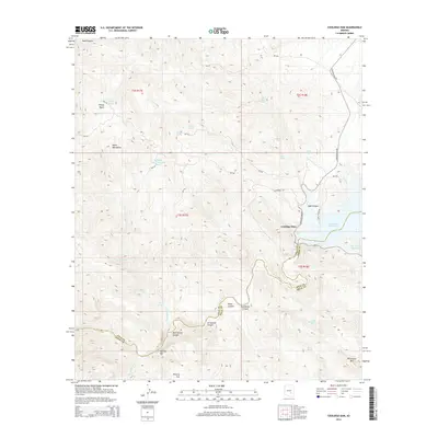
2014 Map of Coolidge Dam
USGS Topo · Published 2014About this map
Coolidge Dam controls the western edge of the San Carlos Reservoir in this arid landscape where the Gila River cuts through the desert. The terrain is marked by significant topographical shifts, from the heights of the Hayes Mountains and Rockhouse Mtn to the low-lying Poverty Flat. The map provides a detailed look at the complex drainage network of the region, featuring named landmarks such as Needles Eye and numerous canyons including Jerusalem Canyon and Dick Spring Canyon.
Find a feature on this map
43 named features on this map. Tap any name to fly to it.
Don’t see what you’re looking for? This feature index may not catch every label — zoom into the map to look around manually.
Map Details
Editions of this 2014 Coolidge Dam Map
This is the sole edition of this map. No revisions or reprints were ever made.
Other maps of this area

1915 · Christmas
USGS Topo · 1:62,500

1917 · Christmas
USGS Topo · 1:62,500

1954 · Mesa
USGS Topo · 1:250,000

1957 · Mesa
USGS Topo · 1:250,000

1958 · Mesa
USGS Topo · 1:250,000

1960 · Mesa
USGS Topo · 1:250,000

1962 · San Carlos Reservoir
USGS Topo · 1:62,500

1964 · Mesa
USGS Topo · 1:250,000

1965 · Bucket Mtn
USGS Topo · 1:24,000
1966 · San Carlos
USGS Topo · 1:24,000