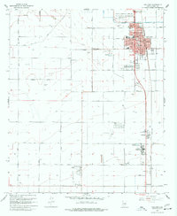
1965 Map of Coolidge
USGS Topo · Published 1977About this map
Casa Grande Ruins National Monument anchors the northern reaches of this mid-1960s survey, where the ancient structures of Clan House 1 stand in contrast to the burgeoning agricultural and aviation infrastructure of the Gila River valley. The town of Coolidge serves as the regional hub, its street grid detailed from Lindbergh Ave to Palo Verde Ave, while the Southern Pacific tracks provide the primary industrial spine. The landscape is defined by an extensive network of irrigation canals and roads such as Vah Ki Inn Road and Kleck Road, which support local farming clusters. Further south, the map documents the sprawling campus of the Arizona Childrens Colony and smaller rural settlements like Randolph and Eleven Mile Corner, reflecting a period of transition as desert lands were increasingly converted to managed agriculture and institutional use.
Find a feature on this map
46 named features on this map. Tap any name to fly to it.
Don’t see what you’re looking for? This feature index may not catch every label — zoom into the map to look around manually.
Map Details
Editions of this 1965 Coolidge Map
3 editions found
Other maps of this area

1900 · Florence
USGS Topo · 1:125,000

1902 · Florence
USGS Topo · 1:125,000

1907 · Sacaton
USGS Topo · 1:62,500

1922 · Red Rock No 2
USGS Topo · 1:48,000

1922 · Signal Peak
USGS Topo · 1:62,500

1924 · Signal Peak
USGS Topo · 1:62,500

1934 · Newman Peak
USGS Topo · 1:125,000

1954 · Mesa
USGS Topo · 1:250,000

1956 · Tucson
USGS Topo · 1:250,000

1957 · Mesa
USGS Topo · 1:250,000