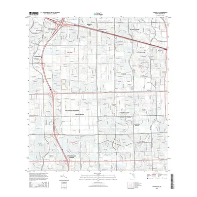
2015 Map of Cooper City
USGS Topo · Published 2015About this map
Cooper City and Pembroke Pines anchor this 2015 survey of Broward County's expanding suburban landscape. The map illustrates a highly managed hydrological environment, where the North New River Canal and South New River Canal delineate residential boundaries. The transition from established neighborhoods in Davie and Plantation to the newer developments of Weston and Southwest Ranches is clearly visible. The terrain is characterized by its flatness, interrupted by the notable Pine Island Ridge and Pine Island. This edition documents the extensive road network connecting major hubs, including the SR 84 corridor and Pines Blvd, alongside specialized features like the Mac-Ivor & Friends Airstrip and several higher education campuses such as American Intercontinental Univ.
Find a feature on this map
32 named features on this map. Tap any name to fly to it.
Don’t see what you’re looking for? This feature index may not catch every label — zoom into the map to look around manually.
Map Details
Editions of this 2015 Cooper City Map
This is the sole edition of this map. No revisions or reprints were ever made.
Other maps of this area

1945 · Fort Lauderdale North
USGS Topo · 1:24,000

1947 · North Miami
USGS Topo · 1:24,000

1949 · Opalocka
USGS Topo · 1:24,000

1949 · Fort Lauderdale North
USGS Topo · 1:24,000

1949 · Fort Lauderdale South
USGS Topo · 1:24,000

1950 · North Miami
USGS Topo · 1:24,000

1956 · Miami
USGS Topo · 1:250,000

1956 · West Palm Beach
USGS Topo · 1:250,000

1957 · West Palm Beach
USGS Topo · 1:250,000

1958 · West Palm Beach
USGS Topo · 1:250,000
Featured Places
- Pembroke Pines, FL
- Cooper City, FL
- Southwest Ranches, FL
- Melaleuca Isles, FL
- Sunshine Ranches, Southwest Ranches