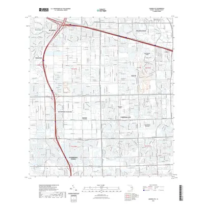
2021 Map of Cooper City
USGS Topo · Published 2021About this map
Cooper City and Southwest Ranches define this densely developed landscape in central Broward County, where residential grids are partitioned by an extensive network of drainage and transportation corridors. The historic North New River Canal and South New River Canal serve as primary east-west arteries, reflecting the region's complex water management history. In the northeastern portion, Pine Island Ridge provides a distinct topographic contrast to the surrounding lowlands, while specialized residential enclaves like Sunshine Ranches and Royal Palm Ranches maintain a different character than the nearby urban hubs of Pembroke Pines and Sunrise. The area is also a regional civic center, housing the Broward County West Regional Courthouse and Trinity International University. Extensive recreational paths, including the Tree Tops Regional Park Trl and Vista View Trl, weave through the suburban fabric, connecting parks to the long-standing canal system.
Find a feature on this map
29 named features on this map. Tap any name to fly to it.
Don’t see what you’re looking for? This feature index may not catch every label — zoom into the map to look around manually.
Map Details
Editions of this 2021 Cooper City Map
This is the sole edition of this map. No revisions or reprints were ever made.
Other maps of this area

1945 · Fort Lauderdale North
USGS Topo · 1:24,000

1947 · North Miami
USGS Topo · 1:24,000

1949 · Opalocka
USGS Topo · 1:24,000

1949 · Fort Lauderdale North
USGS Topo · 1:24,000

1949 · Fort Lauderdale South
USGS Topo · 1:24,000

1950 · North Miami
USGS Topo · 1:24,000

1956 · Miami
USGS Topo · 1:250,000

1956 · West Palm Beach
USGS Topo · 1:250,000

1957 · West Palm Beach
USGS Topo · 1:250,000

1958 · West Palm Beach
USGS Topo · 1:250,000
Featured Places
- Pembroke Pines, FL
- Cooper City, FL
- Southwest Ranches, FL
- Melaleuca Isles, FL
- Sunshine Ranches, Southwest Ranches